 vesseltracker.com
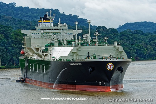
Maria Energy
Current StatusWhere is the vessel?
Maria Energy is currently in 287 nm S of Achau, based on AIS data received about 1h ago.
Latest AIS update:
Current position: 44.12095° N, 160.36835° W (287 nm S of Achau)
Average speed (last 7 days): Loading…
Average speed (last 30 days): Loading…
Vessel profile: Maria Energy is a Lng Tanker with dimensions 46m x 289m.
This page combines live AIS, route history, probable destination signals, nearby traffic, and port activity for practical vessel monitoring.
The current position of vessel Maria Energy is 44.12095 lat / -160.36835 lng. Updated: 2026-05-18 01:36:03 UTCNearest reference points:
- Open sea, approx. 401 nm off the nearest listed port
- Open sea, approx. 402 nm off the nearest listed port
- Open sea, approx. 407 nm off the nearest listed port
Details:
Live Vessel Maria Energy Analytics (details, animations, etc.)
Recent AIS points (UTC):
2026-05-17 21:48:13 UTC · 43.88634, -161.87564 · SOG 15.8 kn · COG 69°2026-05-17 22:51:20 UTC · 43.98329, -161.47055 · SOG 18.2 kn · COG 80°
2026-05-18 00:13:58 UTC · 44.05345, -160.91014 · SOG 17.6 kn · COG 80°
2026-05-18 01:36:03 UTC · 44.12095, -160.36835 · SOG 17.4 kn · COG 80°