 vesseltracker.com
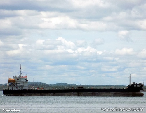
 Sp 2 Bsi
Current Status
Where is the vessel?
Sp 2 Bsi is currently in Near Dumai, based on AIS data received less than 1h ago.
Latest AIS update:
Current position: 1.71207° N, 101.42949° E (Near Dumai)
Average speed (last 7 days): Loading…
Average speed (last 30 days): Loading…
Vessel profile: Sp 2 Bsi is a Bunkering Tanker with dimensions 95m x 15m.
This page combines live AIS, route history, probable destination signals, nearby traffic, and port activity for practical vessel monitoring.
The current position of vessel Sp 2 Bsi is 1.71207 lat / 101.42949 lng. Updated: 2026-05-17 13:30:08 UTCNearest reference points:
- Near Dumai
- 14 nm W of SUNGAI UDANG
- 13 nm SW of PORT DICKSON
Currently sailing under the flag of Indonesia ![]()
Sp 2 Bsi built in 2013 year
Deadweight:
3500 tDetails:
Live Vessel Sp 2 Bsi Analytics (details, animations, etc.)
Recent AIS points (UTC):
2026-05-17 09:04:11 UTC · 1.71167, 101.42833 · SOG 0 kn · COG -1°2026-05-17 10:04:08 UTC · 1.71167, 101.42833 · SOG 0 kn · COG -1°
2026-05-17 11:55:09 UTC · 1.71167, 101.42833 · SOG 0 kn · COG -1°
2026-05-17 13:30:08 UTC · 1.71207, 101.42949 · SOG 0 kn · COG 303°