 vesseltracker.com
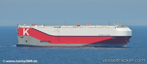
 Polaris Highway
Current Status
Where is the vessel?
Polaris Highway is currently in 104 nm S of Masatepe, based on AIS data received about 1h ago.
Latest AIS update:
Current position: 10.21313° N, 87.77965° W (104 nm S of Masatepe)
Average speed (last 7 days): Loading…
Average speed (last 30 days): Loading…
Vessel profile: Polaris Highway is a Vehicles Carrier with dimensions 199m x 38m.
This page combines live AIS, route history, probable destination signals, nearby traffic, and port activity for practical vessel monitoring.
The current position of vessel Polaris Highway is 10.21313 lat / -87.77965 lng. Updated: 2026-05-18 05:52:36 UTCNearest reference points:
- 27 nm W of Playa Conchal
- Near Golfo de Papagayo
- 67 nm SW of Sámara
Currently sailing under the flag of Panama ![]()
Details:
Live Vessel Polaris Highway Analytics (details, animations, etc.)
Recent AIS points (UTC):
2026-05-18 02:18:44 UTC · 10.58201, -88.54367 · SOG 13.4 kn · COG 118°2026-05-18 04:21:53 UTC · 10.37455, -88.11388 · SOG 14.1 kn · COG 117°
2026-05-18 04:42:22 UTC · 10.33968, -88.03997 · SOG 14.4 kn · COG 119°
2026-05-18 05:52:36 UTC · 10.21313, -87.77965 · SOG 14.8 kn · COG 120°