 vesseltracker.com
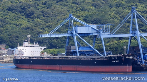
 Ing May
Current Status
Where is the vessel?
Ing May is currently in 101 nm SE of ABURATSU, based on AIS data received about 1h ago.
Latest AIS update:
Current position: 30.62841° N, 133.01863° E (101 nm SE of ABURATSU)
Average speed (last 7 days): Loading…
Average speed (last 30 days): Loading…
Vessel profile: Ing May is a Bulk Carrier with dimensions 228m x 36m.
This page combines live AIS, route history, probable destination signals, nearby traffic, and port activity for practical vessel monitoring.
The current position of vessel Ing May is 30.62841 lat / 133.01863 lng. Updated: 2026-05-17 17:59:36 UTCNearest reference points:
- 77 nm S of Sukumowan
- 190 nm E of NISHINOOMOTE
- Near MIYAZAKI
Currently sailing under the flag of Liberia ![]()
Details:
Live Vessel Ing May Analytics (details, animations, etc.)
Recent AIS points (UTC):
2026-05-17 13:55:54 UTC · 31.29789, 132.72765 · SOG 10.7 kn · COG 158°2026-05-17 15:45:52 UTC · 31.00667, 132.84833 · SOG 10 kn · COG -1°
2026-05-17 16:18:52 UTC · 30.91667, 132.88834 · SOG 10 kn · COG -1°
2026-05-17 17:59:36 UTC · 30.62841, 133.01863 · SOG 11.2 kn · COG 163°