 vesseltracker.com
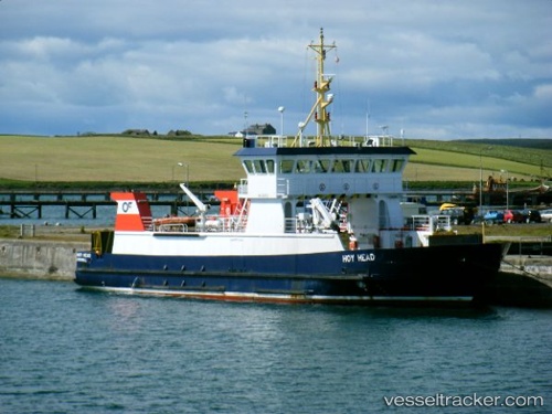
 Hoy Head
Current Status
Where is the vessel?
Hoy Head is currently in Near LONGHOPE, based on AIS data received about 1h ago.
Latest AIS update:
Current position: 58.80117° N, 3.20570° W (Near LONGHOPE)
Average speed (last 7 days): Loading…
Average speed (last 30 days): Loading…
Vessel profile: Hoy Head is a Passenger Ro Ro Cargo Ship with dimensions 50m x 10m.
This page combines live AIS, route history, probable destination signals, nearby traffic, and port activity for practical vessel monitoring.
The current position of vessel Hoy Head is 58.80117 lat / -3.20570 lng. Updated: 2026-05-15 21:25:13 UTCNearest reference points:
- Near STROMNESS
- Near Tingwall
- Near Staxigoe
Currently sailing under the flag of United Kingdom ![]()
Hoy Head built in 1994 year
Deadweight:
137 tDetails:
Live Vessel Hoy Head Analytics (details, animations, etc.)
Recent AIS points (UTC):
2026-05-15 17:35:47 UTC · 58.80993, -3.17529 · SOG 11.2 kn · COG 228°2026-05-15 19:25:24 UTC · 58.80117, -3.20568 · SOG 0 kn · COG 325°
2026-05-15 20:01:16 UTC · 58.80115, -3.20568 · SOG 0 kn · COG 324°
2026-05-15 21:25:13 UTC · 58.80117, -3.20570 · SOG 0 kn · COG 324°