 vesseltracker.com
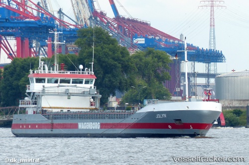
 JOLYN
JOLYN
Current Status
Where is the vessel?
JOLYN is currently in Near Velsen-Noord, based on AIS data received less than 1h ago.
Latest AIS update:
Current position: 52.46954° N, 4.63210° E (Near Velsen-Noord)
Average speed (last 7 days): Loading…
Average speed (last 30 days): Loading…
Vessel profile: JOLYN is a General Cargo Ship with dimensions 90m x 13m.
This page combines live AIS, route history, probable destination signals, nearby traffic, and port activity for practical vessel monitoring.
The current position of vessel JOLYN is 52.46954 lat / 4.63210 lng. Updated: 2026-04-14 05:49:56 UTCNearest reference points:
- Near IJmuiden/Velsen
- Near BEVERWIJK
- Near Ijmuiden
Currently sailing under the flag of Netherlands ![]()
JOLYN built in 2007 year
Deadweight:
3636 tDetails:
Live Vessel JOLYN Analytics (details, animations, etc.)
Recent AIS points (UTC):
2026-04-14 00:19:57 UTC · 52.46948, 4.63215 · SOG 0 kn · COG 81°2026-04-14 02:20:30 UTC · 52.46953, 4.63208 · SOG 0 kn · COG -1°
2026-04-14 03:58:54 UTC · 52.46957, 4.63208 · SOG 0 kn · COG 82°
2026-04-14 05:49:56 UTC · 52.46954, 4.63210 · SOG 0 kn · COG 82°