 vesseltracker.com
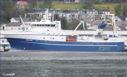
 Volstad
Current Status
Where is the vessel?
Volstad is currently in Near Fiskarstrand, based on AIS data received less than 1h ago.
Latest AIS update:
Current position: 62.44154° N, 6.28017° E (Near Fiskarstrand)
Average speed (last 7 days): Loading…
Average speed (last 30 days): Loading…
Vessel profile: Volstad is a Fishing Vessel with dimensions 74m x 15m.
This page combines live AIS, route history, probable destination signals, nearby traffic, and port activity for practical vessel monitoring.
The current position of vessel Volstad is 62.44154 lat / 6.28017 lng. Updated: 2026-04-27 22:51:43 UTCNearest reference points:
- Near Fiskarstrand
- Near SPJELKAVIK
- Near Alesund
Currently sailing under the flag of Norway ![]()
Volstad built in 2013 year
Deadweight:
1500 tDetails:
Live Vessel Volstad Analytics (details, animations, etc.)
Recent AIS points (UTC):
2026-04-27 19:29:11 UTC · 62.44158, 6.28014 · SOG 0 kn · COG 124°2026-04-27 20:17:12 UTC · 62.44157, 6.28020 · SOG 0 kn · COG 123°
2026-04-27 22:08:12 UTC · 62.44160, 6.28021 · SOG 0 kn · COG 123°
2026-04-27 22:51:43 UTC · 62.44154, 6.28017 · SOG 0 kn · COG 123°