 vesseltracker.com
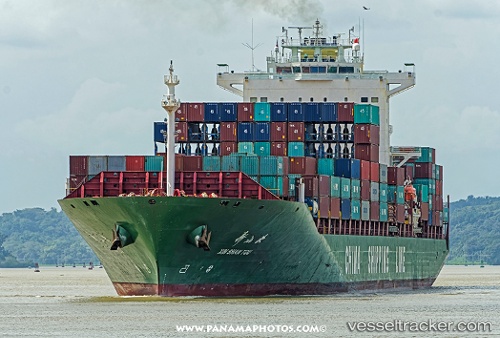
 Xin Shan Tou
Current Status
Where is the vessel?
Xin Shan Tou is currently in 93 nm NE of Achau, based on AIS data received about 1h ago.
Latest AIS update:
Current position: 49.45166° N, 160.46619° W (93 nm NE of Achau)
Average speed (last 7 days): Loading…
Average speed (last 30 days): Loading…
Vessel profile: Xin Shan Tou is a Container Ship with dimensions 263m x 32m.
This page combines live AIS, route history, probable destination signals, nearby traffic, and port activity for practical vessel monitoring.
The current position of vessel Xin Shan Tou is 49.45166 lat / -160.46619 lng. Updated: 2026-04-25 04:25:26 UTCCurrently sailing under the flag of China ![]()
Xin Shan Tou built in 2005 year
Deadweight:
52157 tDetails:
Live Vessel Xin Shan Tou Analytics (details, animations, etc.)
Recent AIS points (UTC):
2026-04-25 01:19:07 UTC · 49.08436, -161.72787 · SOG 18 kn · COG 67°2026-04-25 01:34:21 UTC · 49.11371, -161.62164 · SOG 17.9 kn · COG 68°
2026-04-25 03:23:54 UTC · 49.32138, -160.86865 · SOG 17.9 kn · COG 70°
2026-04-25 04:25:26 UTC · 49.45166, -160.46619 · SOG 16.7 kn · COG 57°