 vesseltracker.com
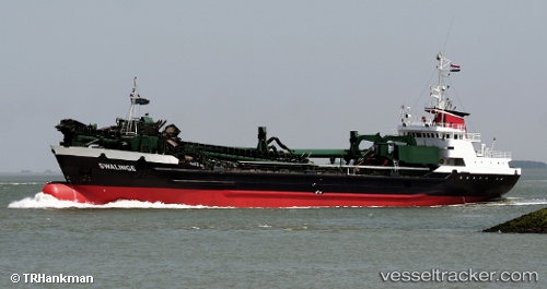
 Swalinge
Current Status
Where is the vessel?
Swalinge is currently in Near Lissewege, based on AIS data received less than 1h ago.
Latest AIS update:
Current position: 51.31200° N, 3.20888° E (Near Lissewege)
Average speed (last 7 days): Loading…
Average speed (last 30 days): Loading…
Vessel profile: Swalinge is a Hopper Dredger with dimensions 81m x 15m.
This page combines live AIS, route history, probable destination signals, nearby traffic, and port activity for practical vessel monitoring.
The current position of vessel Swalinge is 51.31200 lat / 3.20888 lng. Updated: 2026-05-15 01:15:58 UTCNearest reference points:
- Near Zeebrugge
- Near Sas-Slijkens
- Near Oostende
Currently sailing under the flag of Netherlands ![]()
Swalinge built in 1977 year
Deadweight:
3064 tDetails:
Live Vessel Swalinge Analytics (details, animations, etc.)
Recent AIS points (UTC):
2026-05-14 22:01:08 UTC · 51.34150, 3.20585 · SOG 0 kn · COG 127°2026-05-14 22:37:28 UTC · 51.34151, 3.20590 · SOG 0 kn · COG 121°
2026-05-14 23:58:58 UTC · 51.33975, 3.21055 · SOG 2.5 kn · COG 130°
2026-05-15 01:15:58 UTC · 51.31200, 3.20888 · SOG 3.9 kn · COG 255°