 vesseltracker.com
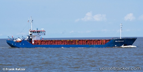
 Celtica Hav
Current Status
Where is the vessel?
Celtica Hav is currently in 25 nm NW of Ile D’Ouessant, based on AIS data received about 1h ago.
Latest AIS update:
Current position: 48.93979° N, 5.97464° W (25 nm NW of Ile D’Ouessant)
Average speed (last 7 days): Loading…
Average speed (last 30 days): Loading…
Vessel profile: Celtica Hav is a Multi Purpose Carrier with dimensions 82m x 11m.
This page combines live AIS, route history, probable destination signals, nearby traffic, and port activity for practical vessel monitoring.
The current position of vessel Celtica Hav is 48.93979 lat / -5.97464 lng. Updated: 2026-05-12 20:05:55 UTCNearest reference points:
- 16 nm NW of Ile D’Ouessant
- 35 nm SW of Ile D’Ouessant
- 18 nm NE of Ile D’Ouessant
Currently sailing under the flag of Bahamas ![]()
Celtica Hav built in 1984 year
Deadweight:
1720 tDetails:
Live Vessel Celtica Hav Analytics (details, animations, etc.)
Recent AIS points (UTC):
2026-05-12 16:21:28 UTC · 49.41517, -5.99740 · SOG 7.8 kn · COG 189°2026-05-12 17:59:42 UTC · 49.20328, -6.00006 · SOG 7.8 kn · COG 177°
2026-05-12 19:13:50 UTC · 49.04470, -5.99978 · SOG 7.3 kn · COG 167°
2026-05-12 20:05:55 UTC · 48.93979, -5.97464 · SOG 7.2 kn · COG 169°