 vesseltracker.com
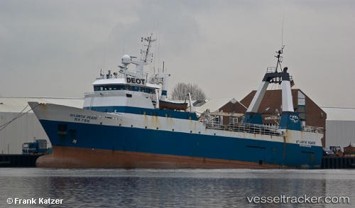
 H.ATLANTIC PEACE
Current Status
Where is the vessel?
H.ATLANTIC PEACE is currently in Near SALDANHA, based on AIS data received less than 1h ago.
Latest AIS update:
Current position: 33.01881° S, 17.95977° E (Near SALDANHA)
Average speed (last 7 days): Loading…
Average speed (last 30 days): Loading…
Vessel profile: H.ATLANTIC PEACE is a Factory Trawler with dimensions m x m.
This page combines live AIS, route history, probable destination signals, nearby traffic, and port activity for practical vessel monitoring.
The current position of vessel H.ATLANTIC PEACE is -33.01881 lat / 17.95977 lng. Updated: 2026-05-01 20:20:02 UTCNearest reference points:
- Near Saint Helena Bay
- Near Laaiplek
- 12 nm W of ROBBEN ISLAND
Currently sailing under the flag of South Africa ![]()
Details:
Live Vessel H.ATLANTIC PEACE Analytics (details, animations, etc.)
Recent AIS points (UTC):
2026-05-01 15:56:02 UTC · -33.01863, 17.96011 · SOG 0 kn · COG -1°2026-05-01 17:50:06 UTC · -33.01870, 17.95978 · SOG 0.2 kn · COG -1°
2026-05-01 19:53:02 UTC · -33.01881, 17.95998 · SOG 0.1 kn · COG -1°
2026-05-01 20:20:02 UTC · -33.01881, 17.95977 · SOG 0.3 kn · COG -1°