 vesseltracker.com
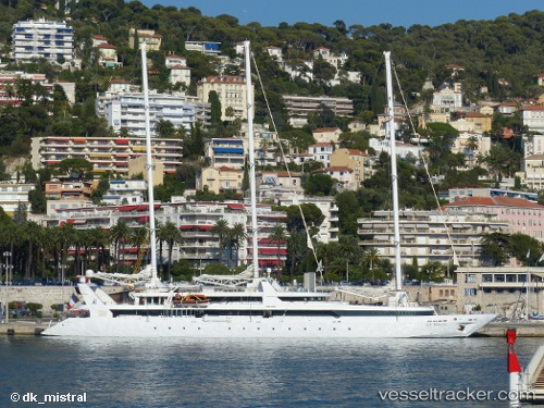
Ponant
Current StatusWhere is the vessel?
Ponant is currently in Near Nice, based on AIS data received less than 1h ago.
Latest AIS update:
Current position: 43.69398° N, 7.28387° E (Near Nice)
Average speed (last 7 days): Loading…
Average speed (last 30 days): Loading…
Vessel profile: Ponant is a Cruise Ship with dimensions 12m x 84m.
This page combines live AIS, route history, probable destination signals, nearby traffic, and port activity for practical vessel monitoring.
The current position of vessel Ponant is 43.69398 lat / 7.28387 lng. Updated: 2026-05-14 05:46:57 UTCNearest reference points:
- Near Nice
- Near Villefranche-sur-Mer
- Near SAINTJEAN CAP FERRAT
Details:
Live Vessel Ponant Analytics (details, animations, etc.)
Recent AIS points (UTC):
2026-05-14 01:30:31 UTC · 43.49435, 7.13914 · SOG 5.5 kn · COG 35°2026-05-14 03:44:02 UTC · 43.66169, 7.27580 · SOG 6.2 kn · COG 21°
2026-05-14 04:34:58 UTC · 43.69399, 7.28390 · SOG 0 kn · COG 327°
2026-05-14 05:46:57 UTC · 43.69398, 7.28387 · SOG 0 kn · COG 327°