 vesseltracker.com
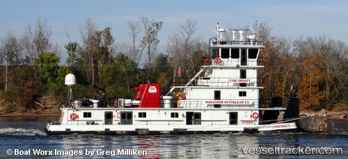
 Cincinnati
Current Status
Where is the vessel?
Cincinnati is currently in Near Morgan Point, based on AIS data received less than 1h ago.
Latest AIS update:
Current position: 29.70798° N, 95.04633° W (Near Morgan Point)
Average speed (last 7 days): Loading…
Average speed (last 30 days): Loading…
Vessel profile: Cincinnati is a Service Ship with dimensions 209m x 221m.
This page combines live AIS, route history, probable destination signals, nearby traffic, and port activity for practical vessel monitoring.
The current position of vessel Cincinnati is 29.70798 lat / -95.04633 lng. Updated: 2026-05-13 02:06:21 UTCNearest reference points:
- Near Morgan Point
- Near Jacinto City
- Near Shoreacres
Currently sailing under the flag of USA ![]()
Details:
Live Vessel Cincinnati Analytics (details, animations, etc.)
Recent AIS points (UTC):
2026-05-12 23:03:56 UTC · 29.70475, -95.04593 · SOG 0 kn · COG -1°2026-05-12 23:47:52 UTC · 29.70472, -95.04594 · SOG 0.1 kn · COG -1°
2026-05-13 01:43:42 UTC · 29.70801, -95.04634 · SOG 0 kn · COG -1°
2026-05-13 02:06:21 UTC · 29.70798, -95.04633 · SOG 0 kn · COG -1°