 vesseltracker.com
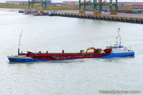
 Ruyter
Current Status
Where is the vessel?
Ruyter is currently in 37 nm SW of Dale Roads, based on AIS data received about 1h ago.
Latest AIS update:
Current position: 51.24932° N, 5.81571° W (37 nm SW of Dale Roads)
Average speed (last 7 days): Loading…
Average speed (last 30 days): Loading…
Vessel profile: Ruyter is a Hopper Dredger with dimensions 82m x 12m.
This page combines live AIS, route history, probable destination signals, nearby traffic, and port activity for practical vessel monitoring.
The current position of vessel Ruyter is 51.24932 lat / -5.81571 lng. Updated: 2026-05-12 21:38:36 UTCNearest reference points:
- 10 nm NW of Grampound
- Near WEXFORD
- Near Falmouth
Currently sailing under the flag of Netherlands ![]()
Ruyter built in 1994 year
Deadweight:
2800 tDetails:
Live Vessel Ruyter Analytics (details, animations, etc.)
Recent AIS points (UTC):
2026-05-12 19:14:02 UTC · 50.77965, -5.84263 · SOG 11.8 kn · COG 3°2026-05-12 20:06:02 UTC · 50.94969, -5.83524 · SOG 11.9 kn · COG 3°
2026-05-12 21:31:37 UTC · 51.22690, -5.81631 · SOG 11.5 kn · COG 1°
2026-05-12 21:38:36 UTC · 51.24932, -5.81571 · SOG 11.4 kn · COG 357°