 vesseltracker.com
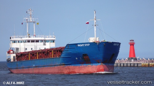
 RIGHT STEP
Current Status
Where is the vessel?
RIGHT STEP is currently in Near Ténès, based on AIS data received less than 1h ago.
Latest AIS update:
Current position: 36.52333° N, 1.29333° E (Near Ténès)
Average speed (last 7 days): Loading…
Average speed (last 30 days): Loading…
Vessel profile: RIGHT STEP is a General Cargo Ship with dimensions 101m x 101m.
This page combines live AIS, route history, probable destination signals, nearby traffic, and port activity for practical vessel monitoring.
The current position of vessel RIGHT STEP is 36.52333 lat / 1.29333 lng. Updated: 2026-05-12 23:06:25 UTCNearest reference points:
- 17 nm S of Albanchez
- Near Mostaganem
- 50 nm N of Mostaganem
Currently sailing under the flag of Antigua and Barbuda ![]()
RIGHT STEP built in 1996 year
Deadweight:
5200 tDetails:
Live Vessel RIGHT STEP Analytics (details, animations, etc.)
Recent AIS points (UTC):
2026-05-12 16:24:25 UTC · 36.52333, 1.29333 · SOG 0 kn · COG -1°2026-05-12 21:48:25 UTC · 36.52500, 1.29333 · SOG 0 kn · COG -1°
2026-05-12 22:24:22 UTC · 36.52500, 1.29333 · SOG 0 kn · COG -1°
2026-05-12 23:06:25 UTC · 36.52333, 1.29333 · SOG 0 kn · COG -1°