 vesseltracker.com
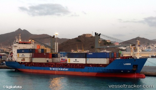
 LAGOA
LAGOA
Current Status
Where is the vessel?
LAGOA is currently in 69 nm NW of Las Brujas, based on AIS data received less than 1h ago.
Latest AIS update:
Current position: 24.12989° N, 19.43447° W (69 nm NW of Las Brujas)
Average speed (last 7 days): Loading…
Average speed (last 30 days): Loading…
Vessel profile: LAGOA is a General Cargo with dimensions m x m.
This page combines live AIS, route history, probable destination signals, nearby traffic, and port activity for practical vessel monitoring.
The current position of vessel LAGOA is 24.12989 lat / -19.43447 lng. Updated: 2026-05-16 17:48:20 UTCNearest reference points:
- 110 nm NE of Las Brujas
Currently sailing under the flag of Portugal ![]()
Details:
Live Vessel LAGOA Analytics (details, animations, etc.)
Recent AIS points (UTC):
2026-05-16 13:24:52 UTC · 24.99959, -18.74463 · SOG 14.3 kn · COG 217°2026-05-16 15:39:33 UTC · 24.55833, -19.09333 · SOG 14 kn · COG -1°
2026-05-16 17:03:30 UTC · 24.27833, -19.31500 · SOG 14 kn · COG -1°
2026-05-16 17:48:20 UTC · 24.12989, -19.43447 · SOG 14.9 kn · COG 216°