 vesseltracker.com
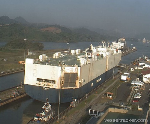
New Century 2
Current StatusWhere is the vessel?
New Century 2 is currently in Open sea (no nearby ports in database), based on AIS data received less than 1h ago.
Latest AIS update:
Current position: 41.60922° N, 164.33835° W (Open sea (no nearby ports in database))
Average speed (last 7 days): Loading…
Average speed (last 30 days): Loading…
Vessel profile: New Century 2 is a Vehicles Carrier with dimensions 32m x 200m.
This page combines live AIS, route history, probable destination signals, nearby traffic, and port activity for practical vessel monitoring.
The current position of vessel New Century 2 is 41.60922 lat / -164.33835 lng. Updated: 2026-05-16 04:23:45 UTCNearest reference points:
- Open sea (no nearby ports in database)
- Open sea, approx. 401 nm off the nearest listed port
- Open sea, approx. 403 nm off the nearest listed port
Details:
Live Vessel New Century 2 Analytics (details, animations, etc.)
Recent AIS points (UTC):
2026-05-16 01:22:18 UTC · 41.47699, -165.46960 · SOG 17 kn · COG 83°2026-05-16 01:34:08 UTC · 41.48490, -165.39694 · SOG 16.6 kn · COG 82°
2026-05-16 04:11:00 UTC · 41.59847, -164.41698 · SOG 16.9 kn · COG 80°
2026-05-16 04:23:45 UTC · 41.60922, -164.33835 · SOG 16.7 kn · COG 83°