 vesseltracker.com
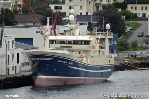
 GUNNAR
Current Status
Where is the vessel?
GUNNAR is currently in 22 nm N of Kropa, based on AIS data received less than 1h ago.
Latest AIS update:
Current position: 46.65167° N, 141.24333° E (22 nm N of Kropa)
Average speed (last 7 days): Loading…
Average speed (last 30 days): Loading…
Vessel profile: GUNNAR is a Fishing Vessel with dimensions 14m x 75m.
This page combines live AIS, route history, probable destination signals, nearby traffic, and port activity for practical vessel monitoring.
The current position of vessel GUNNAR is 46.65167 lat / 141.24333 lng. Updated: 2026-05-01 22:01:21 UTCNearest reference points:
- 40 nm NW of NEVELSK
- Near NEVELSK
- Near Kholmsk
Currently sailing under the flag of Russia ![]()
GUNNAR built in 2003 year
Deadweight:
2446 tDetails:
Live Vessel GUNNAR Analytics (details, animations, etc.)
Recent AIS points (UTC):
2026-05-01 19:23:24 UTC · 46.68657, 141.44058 · SOG 3.9 kn · COG 194°2026-05-01 19:29:57 UTC · 46.67949, 141.43826 · SOG 3.9 kn · COG 195°
2026-05-01 20:28:26 UTC · 46.63833, 141.37666 · SOG 3 kn · COG -1°
2026-05-01 22:01:21 UTC · 46.65167, 141.24333 · SOG 3 kn · COG -1°