 vesseltracker.com
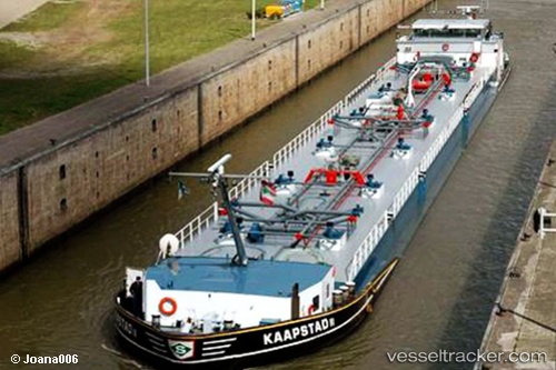
 Kaapstad
Current Status
Where is the vessel?
Kaapstad is currently in Near MAASVLAKTE - ROTTERDAM, based on AIS data received less than 1h ago.
Latest AIS update:
Current position: 51.93703° N, 4.07580° E (Near MAASVLAKTE - ROTTERDAM)
Average speed (last 7 days): Loading…
Average speed (last 30 days): Loading…
Vessel profile: Kaapstad is a Other Tanker with dimensions 135m x 15m.
This page combines live AIS, route history, probable destination signals, nearby traffic, and port activity for practical vessel monitoring.
The current position of vessel Kaapstad is 51.93703 lat / 4.07580 lng. Updated: 2026-05-14 22:37:08 UTCNearest reference points:
- Near MAASVLAKTE - ROTTERDAM
- Near HOEK VAN HOLLAND
- Near Rockanje
Currently sailing under the flag of Belgium ![]()
Details:
Live Vessel Kaapstad Analytics (details, animations, etc.)
Recent AIS points (UTC):
2026-05-14 19:42:41 UTC · 51.93704, 4.07582 · SOG 0 kn · COG 76°2026-05-14 19:58:40 UTC · 51.93704, 4.07582 · SOG 0 kn · COG 76°
2026-05-14 22:01:08 UTC · 51.93702, 4.07581 · SOG 0 kn · COG 77°
2026-05-14 22:37:08 UTC · 51.93703, 4.07580 · SOG 0 kn · COG 76°