 vesseltracker.com
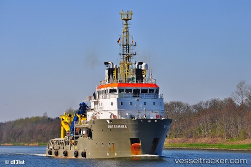
Kamara
Current StatusWhere is the vessel?
Kamara is currently in 12 nm NW of Oostende, based on AIS data received less than 1h ago.
Latest AIS update:
Current position: 51.40957° N, 2.75694° E (12 nm NW of Oostende)
Average speed (last 7 days): Loading…
Average speed (last 30 days): Loading…
Vessel profile: Kamara is a Offshore Tug Supply Ship with dimensions 16m x 72m.
This page combines live AIS, route history, probable destination signals, nearby traffic, and port activity for practical vessel monitoring.
The current position of vessel Kamara is 51.40957 lat / 2.75694 lng. Updated: 2026-05-16 12:23:19 UTCNearest reference points:
- 13 nm NW of Middelkerke
- Near Oostende
- Near Sas-Slijkens
Details:
Live Vessel Kamara Analytics (details, animations, etc.)
Recent AIS points (UTC):
2026-05-16 07:43:00 UTC · 51.41031, 2.75735 · SOG 0.5 kn · COG 56°2026-05-16 09:35:19 UTC · 51.41024, 2.75656 · SOG 0.2 kn · COG 18°
2026-05-16 10:02:59 UTC · 51.41024, 2.75656 · SOG 0.2 kn · COG 18°
2026-05-16 12:23:19 UTC · 51.40957, 2.75694 · SOG 0.3 kn · COG 243°