 vesseltracker.com
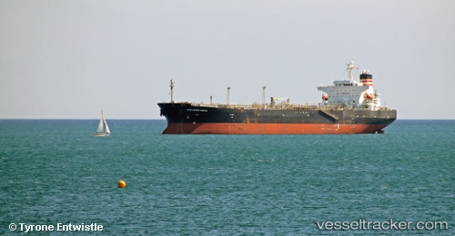
 VELOS FORTUNA
Current Status
Where is the vessel?
VELOS FORTUNA is currently in Open sea, approx. 432 nm off the nearest listed port, based on AIS data received about 1h ago.
Latest AIS update:
Current position: 14.26057° N, 42.68828° W (Open sea, approx. 432 nm off the nearest listed port)
Average speed (last 7 days): Loading…
Average speed (last 30 days): Loading…
Vessel profile: VELOS FORTUNA is a Oil Products Tanker with dimensions 32m x 182m.
This page combines live AIS, route history, probable destination signals, nearby traffic, and port activity for practical vessel monitoring.
The current position of vessel VELOS FORTUNA is 14.26057 lat / -42.68828 lng. Updated: 2026-04-02 23:58:14 UTCNearest reference points:
- Open sea, approx. 432 nm off the nearest listed port
- Open sea, approx. 427 nm off the nearest listed port
- Open sea (no nearby ports in database)
Currently sailing under the flag of Marshall Islands ![]()
VELOS FORTUNA built in 2007 year
Deadweight:
47286 tDetails:
Live Vessel VELOS FORTUNA Analytics (details, animations, etc.)
Recent AIS points (UTC):
2026-04-02 18:02:24 UTC · 13.35515, -41.70985 · SOG 13.3 kn · COG 315°2026-04-02 19:45:03 UTC · 13.61415, -41.98702 · SOG 12.9 kn · COG 316°
2026-04-02 21:38:13 UTC · 13.90433, -42.29792 · SOG 13.4 kn · COG 314°
2026-04-02 23:58:14 UTC · 14.26057, -42.68828 · SOG 13.3 kn · COG 317°