 vesseltracker.com
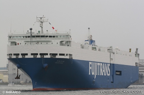
 Kinuura Maru
Current Status
Where is the vessel?
Kinuura Maru is currently in Near Yokosuka, based on AIS data received less than 1h ago.
Latest AIS update:
Current position: 35.19807° N, 139.76328° E (Near Yokosuka)
Average speed (last 7 days): Loading…
Average speed (last 30 days): Loading…
Vessel profile: Kinuura Maru is a Vehicles Carrier with dimensions 165m x 28m.
This page combines live AIS, route history, probable destination signals, nearby traffic, and port activity for practical vessel monitoring.
The current position of vessel Kinuura Maru is 35.19807 lat / 139.76328 lng. Updated: 2026-05-17 10:27:44 UTCNearest reference points:
- Near Yokosuka
- Near Naka-Ku, Kanagawa
- 15 nm S of Zushi
Currently sailing under the flag of Japan ![]()
Kinuura Maru built in 2007 year
Deadweight:
5820 tDetails:
Live Vessel Kinuura Maru Analytics (details, animations, etc.)
Recent AIS points (UTC):
2026-05-17 07:23:12 UTC · 35.38995, 139.64784 · SOG 0 kn · COG 115°2026-05-17 07:29:11 UTC · 35.38995, 139.64783 · SOG 0 kn · COG 115°
2026-05-17 09:42:40 UTC · 35.34231, 139.70203 · SOG 12.9 kn · COG 155°
2026-05-17 10:27:44 UTC · 35.19807, 139.76328 · SOG 13.6 kn · COG 203°