 vesseltracker.com
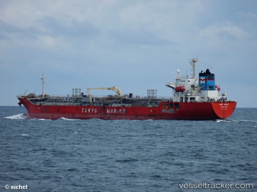
 EASTERLY LIME GALAXY
Current Status
Where is the vessel?
EASTERLY LIME GALAXY is currently in 155 nm SE of Quintana, based on AIS data received less than 1h ago.
Latest AIS update:
Current position: 26.66856° N, 93.86667° W (155 nm SE of Quintana)
Average speed (last 7 days): Loading…
Average speed (last 30 days): Loading…
Vessel profile: EASTERLY LIME GALAXY is a Chemical/Oil Products Tanker with dimensions 23m x 145m.
This page combines live AIS, route history, probable destination signals, nearby traffic, and port activity for practical vessel monitoring.
The current position of vessel EASTERLY LIME GALAXY is 26.66856 lat / -93.86667 lng. Updated: 2026-05-15 07:13:05 UTCNearest reference points:
- 63 nm SE of Quintana
- 56 nm SE of Quintana
- 97 nm W of Gulfmex Lightering Area
Currently sailing under the flag of Marshall Islands ![]()
EASTERLY LIME GALAXY built in 2008 year
Deadweight:
19992 tDetails:
Live Vessel EASTERLY LIME GALAXY Analytics (details, animations, etc.)
Recent AIS points (UTC):
2026-05-15 03:52:43 UTC · 27.22868, -94.34632 · SOG 12.7 kn · COG 145°2026-05-15 04:47:58 UTC · 27.07305, -94.21235 · SOG 12.6 kn · COG 141°
2026-05-15 05:04:35 UTC · 27.02735, -94.17213 · SOG 12.6 kn · COG 141°
2026-05-15 07:13:05 UTC · 26.66856, -93.86667 · SOG 12.5 kn · COG 146°