 vesseltracker.com
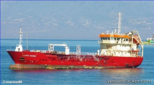
Harpa Doris
Current StatusWhere is the vessel?
Harpa Doris is currently in 13 nm N of Sao Filipe, based on AIS data received about 1h ago.
Latest AIS update:
Current position: 15.10500° N, 24.59166° W (13 nm N of Sao Filipe)
Average speed (last 7 days): Loading…
Average speed (last 30 days): Loading…
Vessel profile: Harpa Doris is a Chemical Oil Products Tanker with dimensions 12m x 69m.
This page combines live AIS, route history, probable destination signals, nearby traffic, and port activity for practical vessel monitoring.
The current position of vessel Harpa Doris is 15.10500 lat / -24.59166 lng. Updated: 2026-05-15 16:06:16 UTCNearest reference points:
- 39 nm W of Ilha do Sal
- Near Ilha do Sal
Details:
Live Vessel Harpa Doris Analytics (details, animations, etc.)
Recent AIS points (UTC):
2026-05-15 13:24:15 UTC · 14.87500, -24.49167 · SOG 0 kn · COG -1°2026-05-15 13:27:14 UTC · 14.87500, -24.49167 · SOG 0 kn · COG -1°
2026-05-15 15:27:17 UTC · 15.03333, -24.56833 · SOG 6 kn · COG -1°
2026-05-15 16:06:16 UTC · 15.10500, -24.59166 · SOG 7 kn · COG -1°