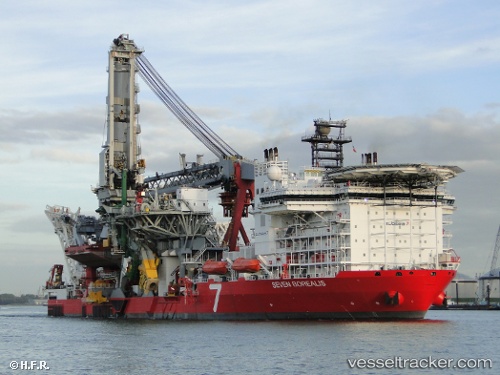
.
Vessel photo of Seven Borealis (IMO 9452787) vesseltracker.com

BS flag Seven Borealis

Vessel type: Pipe Layer | IMO: 9452787 | MMSI: MMSI: 311031900
Call sign: C6YG8 | Dimensions: 182 m x 46 m
Current Status

Where is the vessel?

Seven Borealis is currently in 91 nm SE of Elvillar, based on AIS data received about 15h ago.

Latest AIS update:

Current position: 41.22349° N, 19.57155° W (91 nm SE of Elvillar)

Average speed (last 7 days): Loading…

Average speed (last 30 days): Loading…

Vessel profile: Seven Borealis is a Pipe Layer with dimensions 182m x 46m.

This page combines live AIS, route history, probable destination signals, nearby traffic, and port activity for practical vessel monitoring.

The current position of vessel Seven Borealis is 41.22349 lat / -19.57155 lng. Updated: 2026-03-26 06:20:19 UTC
Nearest reference points:
  • 48 nm S of Elvillar

Currently sailing under the flag of Bahamas BS flag

Seven Borealis built in 2012 year

Deadweight:
47000 t

Details:

Live Vessel Seven Borealis Analytics (details, animations, etc.)


Recent AIS points (UTC):
2026-03-26 05:36:55 UTC · 41.16358, -19.66982 · SOG 8.1 kn · COG 53°
2026-03-26 06:20:19 UTC · 41.22349, -19.57155 · SOG 8.2 kn · COG 51°

Track of the vessel in the last 28 days


UTC: --
Start: -- Track timeline (UTC) End: --
Encountered: --


Link to the map:


Find another ship

Seven_Borealis (311031900) last ports (portcalls and passsages)

Luanda | 2025-09-15 12:40:17
Luanda | 2025-09-08 11:14:33
CLOV FPSO | 2025-09-02 14:42:48
Luanda | 2025-07-09 05:24:27
Luanda | 2025-06-23 09:57:25
Luanda | 2025-06-07 10:09:52
Luanda | 2025-06-03 10:04:30
Luanda | 2025-05-30 09:43:49
Luanda | 2025-05-26 09:11:42
Luanda | 2025-05-22 08:33:49
Luanda | 2025-05-18 07:25:48
Luanda | 2025-05-14 06:24:50
Luanda | 2025-04-29 05:44:07
Luanda | 2025-04-25 05:25:37
WALVIS BAY | 2025-04-16 06:05:20
ROBBEN ISLAND | 2025-04-09 03:13:51
ROBBEN ISLAND | 2025-04-03 07:23:33
Cape Town | 2025-04-03 07:01:15
HOUT BAY | 2025-04-03 05:48:20
Cape Of Good Hope | 2025-04-03 04:00:40
KHALIFA | 2025-03-07 07:24:37
KHALIFA | 2025-03-03 07:07:54
KHALIFA | 2025-02-27 06:54:59
KHALIFA | 2025-02-23 06:05:22
Ras Tannurah | 2024-09-29 03:59:35
Cape Town | 2024-07-30 05:19:04
Bridgetown | 2024-06-27 12:19:41
Bridgetown | 2024-06-23 10:49:37
Bridgetown | 2024-06-19 10:06:31
Bridgetown | 2024-06-15 09:22:10
Bridgetown | 2024-03-28 03:26:34
Bridgetown | 2024-03-23 09:11:15
Cape Town | 2024-02-28 20:23:04
Cape Of Good Hope | 2024-02-28 17:10:46
Ras Tannurah | 2024-01-11 02:01:44
Ras Tannurah | 2023-05-20 04:30:56
Cape Of Good Hope | 2023-04-16 21:42:52
Walvisbaai | 2023-04-09 10:32:58
Luanda | 2023-03-31 13:02:31
Luanda | 2023-02-16 05:08:27
Luanda | 2023-02-12 02:16:15
Luanda | 2023-01-13 05:17:33
Luanda | 2023-01-09 05:05:34
Luanda | 2023-01-05 02:13:12
Luanda | 2022-12-31 23:27:04
Pointe Noire | 2022-12-29 23:13:31
Galeota Point | 2022-11-29 20:46:19
Galeota Point | 2022-11-23 23:43:28
Galeota Point | 2022-09-29 17:01:09
Galeota Point | 2022-09-25 13:42:25
Galeota Point | 2022-09-21 13:23:26
Bridgetown | 2022-09-09 19:35:57
Ponta Delgada | 2022-08-30 07:36:10
Vlaardingen | 2022-03-24 03:35:13
Vigo | 2022-03-09 09:11:27
Takoradi | 2022-02-21 17:35:43
Takoradi | 2022-02-19 23:30:39
Takoradi | 2022-02-19 20:13:01
Takoradi | 2022-02-02 06:27:37