 vesseltracker.com
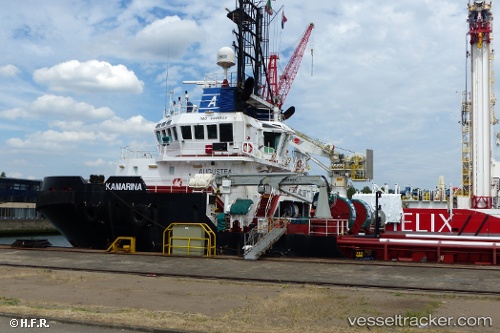
 Kamarina
Current Status
Where is the vessel?
Kamarina is currently in Near SASSNITZ, based on AIS data received less than 1h ago.
Latest AIS update:
Current position: 54.48908° N, 13.82115° E (Near SASSNITZ)
Average speed (last 7 days): Loading…
Average speed (last 30 days): Loading…
Vessel profile: Kamarina is a Tug with dimensions 50m x 15m.
This page combines live AIS, route history, probable destination signals, nearby traffic, and port activity for practical vessel monitoring.
The current position of vessel Kamarina is 54.48908 lat / 13.82115 lng. Updated: 2026-05-16 04:03:13 UTCNearest reference points:
- Near Baabe (Ostseebad)
- Near SASSNITZ
- Near Lietzow
Currently sailing under the flag of Italy ![]()
Kamarina built in 2010 year
Deadweight:
1268 tDetails:
Live Vessel Kamarina Analytics (details, animations, etc.)
Recent AIS points (UTC):
2026-05-16 01:28:03 UTC · 54.57202, 14.05758 · SOG 3.8 kn · COG 236°2026-05-16 01:50:43 UTC · 54.55907, 14.02265 · SOG 3.7 kn · COG 237°
2026-05-16 03:22:43 UTC · 54.51058, 13.88282 · SOG 3.7 kn · COG 242°
2026-05-16 04:03:13 UTC · 54.48908, 13.82115 · SOG 3.6 kn · COG 245°