 vesseltracker.com
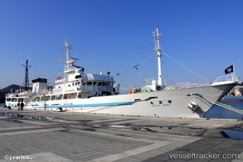
Kaiyumaru
Current StatusWhere is the vessel?
Kaiyumaru is currently in 230 nm NW of Johnston Island, based on AIS data received about 1h ago.
Latest AIS update:
Current position: 19.00129° N, 172.76540° W (230 nm NW of Johnston Island)
Average speed (last 7 days): Loading…
Average speed (last 30 days): Loading…
Vessel profile: Kaiyumaru is a Training Ship with dimensions 10m x 68m.
This page combines live AIS, route history, probable destination signals, nearby traffic, and port activity for practical vessel monitoring.
The current position of vessel Kaiyumaru is 19.00129 lat / -172.76540 lng. Updated: 2026-05-13 20:14:04 UTCNearest reference points:
- Open sea, approx. 406 nm off the nearest listed port
- Open sea, approx. 408 nm off the nearest listed port
- Open sea, approx. 411 nm off the nearest listed port
Details:
Live Vessel Kaiyumaru Analytics (details, animations, etc.)
Recent AIS points (UTC):
2026-05-13 16:48:24 UTC · 18.87480, -173.40236 · SOG 10.4 kn · COG 69°2026-05-13 17:32:24 UTC · 18.91482, -173.27316 · SOG 10.5 kn · COG 70°
2026-05-13 19:38:54 UTC · 18.99995, -172.87817 · SOG 10.9 kn · COG 87°
2026-05-13 20:14:04 UTC · 19.00129, -172.76540 · SOG 10.9 kn · COG 88°