 vesseltracker.com
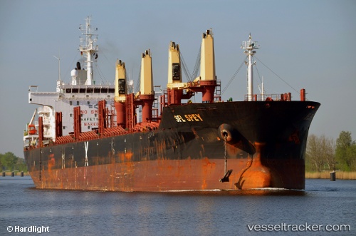
 CLIPPER SPEY
Current Status
Where is the vessel?
CLIPPER SPEY is currently in 67 nm SW of Terempa, based on AIS data received about 1d ago.
Latest AIS update:
Current position: 2.77165° N, 105.18839° E (67 nm SW of Terempa)
Average speed (last 7 days): Loading…
Average speed (last 30 days): Loading…
Vessel profile: CLIPPER SPEY is a Bulk Carrier with dimensions 30m x 181m.
This page combines live AIS, route history, probable destination signals, nearby traffic, and port activity for practical vessel monitoring.
The current position of vessel CLIPPER SPEY is 2.77165 lat / 105.18839 lng. Updated: 2026-04-10 07:31:45 UTCNearest reference points:
- 80 nm SW of Terempa
- 64 nm NE of PENGERANG
- 55 nm NE of PENGERANG
Currently sailing under the flag of Marshall Islands ![]()
CLIPPER SPEY built in 2011 year
Deadweight:
33985 tDetails:
Live Vessel CLIPPER SPEY Analytics (details, animations, etc.)
Recent AIS points (UTC):
2026-04-10 01:35:01 UTC · 1.85395, 104.80718 · SOG 10 kn · COG -1°2026-04-10 04:14:57 UTC · 2.27635, 104.95713 · SOG 10.1 kn · COG 25°
2026-04-10 05:48:16 UTC · 2.51487, 105.06802 · SOG 10 kn · COG 27°
2026-04-10 07:31:45 UTC · 2.77165, 105.18839 · SOG 9.9 kn · COG 27°