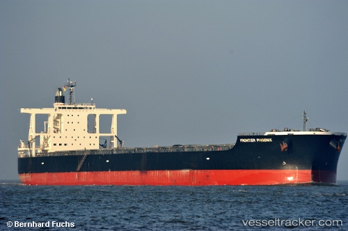
.
Vessel photo of CAPE PHOENIX (IMO 9598139) vesseltracker.com

LB flag CAPE PHOENIX

Vessel type: Bulk Carrier | IMO: 9598139 | MMSI: MMSI: 636021281
Call sign: 5LDE3 | Dimensions: 292 m x 292 m
Current Status

Where is the vessel?

CAPE PHOENIX is currently in 25 nm E of Açu Pt/São João da Barra, based on AIS data received about 1h ago.

Latest AIS update:

Current position: 21.95223° S, 40.56229° W (25 nm E of Açu Pt/São João da Barra)

Average speed (last 7 days): Loading…

Average speed (last 30 days): Loading…

Vessel profile: CAPE PHOENIX is a Bulk Carrier with dimensions 292m x 292m.

This page combines live AIS, route history, probable destination signals, nearby traffic, and port activity for practical vessel monitoring.

The current position of vessel CAPE PHOENIX is -21.95223 lat / -40.56229 lng. Updated: 2026-03-28 15:33:49 UTC
Nearest reference points:
  • Near PORTO DO ACU
  • Near Fluminense FPSO
  • Near Capixaba FPSO

Currently sailing under the flag of Liberia LB flag

CAPE PHOENIX built in 2011 year

Deadweight:
181356 t

Details:

Live Vessel CAPE PHOENIX Analytics (details, animations, etc.)


Recent AIS points (UTC):
2026-03-28 09:52:27 UTC · -22.45413, -41.12300 · SOG 7.4 kn · COG 46°
2026-03-28 11:34:07 UTC · -22.30014, -40.95337 · SOG 7.6 kn · COG 42°
2026-03-28 14:05:19 UTC · -22.08743, -40.69673 · SOG 7.8 kn · COG 50°
2026-03-28 15:33:49 UTC · -21.95223, -40.56229 · SOG 7.9 kn · COG 324°

Track of the vessel in the last 28 days


UTC: --
Start: -- Track timeline (UTC) End: --
Encountered: --


Link to the map:


Find another ship

CAPE_PHOENIX (636021281) last ports (portcalls and passsages)

Thetis Island | 2025-09-14 12:06:21
Thetis Island | 2025-09-08 10:52:39
Thetis Island | 2025-09-02 14:49:51
Mayne | 2025-09-02 14:05:13
Victoria | 2025-09-02 10:37:55
Tsugaru-Kaikyo | 2025-08-18 21:58:12
KITAKYUSHU | 2025-08-14 01:23:09
Shimonoseki | 2025-08-13 23:39:53
Ube | 2025-08-13 22:30:57
SUMOTO | 2025-08-12 05:18:42
AKASHI | 2025-08-12 02:59:04
TAKASAGO | 2025-08-08 05:01:30
TAKASAGO | 2025-08-04 04:59:27
AKASHI | 2025-08-04 02:54:47
PULAU SAMBU | 2025-05-07 11:17:03
TANAH MERAH | 2025-05-06 16:57:15
PENGERANG | 2025-05-06 16:11:27
Dagu Bar | 2025-04-24 15:04:30
Taku Bar | 2025-04-24 13:22:22
TANAH MERAH | 2025-04-11 17:06:13
PULAU SAMBU | 2025-04-11 15:24:10
Cape Of Good Hope | 2025-03-17 08:40:24
BUKOM ISLAND | 2025-01-08 13:49:06
BATU AMPAR | 2025-01-08 12:48:51
TANAH MERAH | 2025-01-08 09:53:46
BATU AMPAR | 2025-01-04 09:46:22
TANAH MERAH | 2025-01-04 08:49:03
PENGERANG | 2025-01-04 07:25:17
Dampier | 2024-11-26 11:46:18
Taicang | 2024-11-11 15:34:15
Wusong | 2024-11-11 12:28:50
Jingjiang | 2024-11-11 07:22:21
ZHOUSHAN | 2024-11-05 23:54:53
Selat Lombok | 2024-10-22 06:27:28
Port Headland | 2024-10-18 05:20:13
Selat Lombok | 2024-09-14 00:43:39
Port Headland | 2024-09-09 19:59:45
Selat Lombok | 2024-09-07 04:44:29
Kaohsiung | 2024-08-29 04:23:54
Kaohsiung | 2024-08-25 03:43:10
Selat Lombok | 2024-08-17 17:37:07
Samson Point | 2024-08-12 12:00:07
Jingjiang | 2024-07-29 15:28:21
Wusong | 2024-07-29 11:26:22
Zhangjiagang | 2024-07-27 10:04:38
Nantong | 2024-07-27 06:36:48
Taicang | 2024-07-27 02:43:19
Wusong | 2024-07-25 06:47:39
Jingjiang | 2024-07-24 08:30:08
Samson Point | 2024-07-05 13:06:21
Come By Chance | 2024-03-31 23:33:23
Argentia | 2024-03-31 21:01:07
Pentland Firth | 2024-03-21 20:50:29
Cuxhaven | 2024-03-19 20:24:42
Saldanha Bay | 2024-02-17 18:43:56
Sambu | 2024-01-30 08:33:05
Selat Lombok | 2023-12-07 21:18:32
Xiamen | 2023-11-27 04:22:08
Selat Lombok | 2023-11-10 03:15:40
Samson Point | 2023-11-05 08:12:55
Taicang | 2023-10-20 10:52:25
Zhangjiagang | 2023-10-20 06:44:27
Nantong | 2023-10-18 09:36:44
Wusong | 2023-10-18 05:18:07
Jingjiang | 2023-10-18 00:28:27
Lianyungang | 2023-10-15 02:49:44
Singapore | 2023-10-02 22:33:20
Singapore | 2023-07-10 03:08:49
Wusong | 2023-06-30 08:35:34
Taicang | 2023-06-30 06:57:07
Singapore | 2023-03-08 12:03:06
Dampier | 2023-01-23 11:33:49