 vesseltracker.com
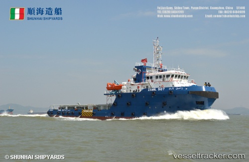
 ZAMIL 507
Current Status
Where is the vessel?
ZAMIL 507 is currently in 21 nm NW of Ras Al Khair, based on AIS data received less than 1h ago.
Latest AIS update:
Current position: 27.78300° N, 48.87341° E (21 nm NW of Ras Al Khair)
Average speed (last 7 days): Loading…
Average speed (last 30 days): Loading…
Vessel profile: ZAMIL 507 is a Tug with dimensions m x m.
This page combines live AIS, route history, probable destination signals, nearby traffic, and port activity for practical vessel monitoring.
The current position of vessel ZAMIL 507 is 27.78300 lat / 48.87341 lng. Updated: 2026-04-24 22:06:56 UTCNearest reference points:
- Near Bandar Al Mishab
- Near Ras Al Khair
- 29 nm E of Bandar Al Mishab
Currently sailing under the flag of Saudi Arabia ![]()
Details:
Live Vessel ZAMIL 507 Analytics (details, animations, etc.)
Recent AIS points (UTC):
2026-04-24 18:29:55 UTC · 28.15103, 49.33399 · SOG 6.5 kn · COG 177°2026-04-24 18:29:55 UTC · 28.15103, 49.33399 · SOG 6.5 kn · COG 177°
2026-04-24 21:22:17 UTC · 27.78299, 48.87341 · SOG 0 kn · COG 0°
2026-04-24 22:06:56 UTC · 27.78300, 48.87341 · SOG 0 kn · COG 0°