 vesseltracker.com
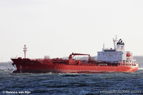
 LOEVSTAKKEN
Current Status
Where is the vessel?
LOEVSTAKKEN is currently in 97 nm NE of Arthur's Town, Cat Island, based on AIS data received about 2h ago.
Latest AIS update:
Current position: 25.99951° N, 74.76305° W (97 nm NE of Arthur's Town, Cat Island)
Average speed (last 7 days): Loading…
Average speed (last 30 days): Loading…
Vessel profile: LOEVSTAKKEN is a Chemical/Oil Products Tanker with dimensions 147m x 24m.
This page combines live AIS, route history, probable destination signals, nearby traffic, and port activity for practical vessel monitoring.
The current position of vessel LOEVSTAKKEN is 25.99951 lat / -74.76305 lng. Updated: 2026-03-27 05:03:26 UTCNearest reference points:
- 31 nm E of Harbour Island
- 22 nm E of Harbour Island
- Near Harbour Island
Currently sailing under the flag of Norway (NIS) ![]()
LOEVSTAKKEN built in 2015 year
Deadweight:
19996 tDetails:
Live Vessel LOEVSTAKKEN Analytics (details, animations, etc.)
Recent AIS points (UTC):
2026-03-26 23:27:39 UTC · 26.15467, -73.50465 · SOG 12.5 kn · COG 265°2026-03-27 01:38:54 UTC · 26.10766, -74.01436 · SOG 12.2 kn · COG 260°
2026-03-27 03:32:47 UTC · 26.04896, -74.42928 · SOG 12 kn · COG 256°
2026-03-27 05:03:26 UTC · 25.99951, -74.76305 · SOG 12.4 kn · COG 256°