 vesseltracker.com
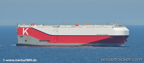
 Polaris Highway
Current Status
Where is the vessel?
Polaris Highway is currently in 294 nm W of Punta Baja, based on AIS data received less than 1h ago.
Latest AIS update:
Current position: 28.38204° N, 121.13038° W (294 nm W of Punta Baja)
Average speed (last 7 days): Loading…
Average speed (last 30 days): Loading…
Vessel profile: Polaris Highway is a Vehicles Carrier with dimensions 199m x 38m.
This page combines live AIS, route history, probable destination signals, nearby traffic, and port activity for practical vessel monitoring.
The current position of vessel Polaris Highway is 28.38204 lat / -121.13038 lng. Updated: 2026-05-13 04:23:02 UTCNearest reference points:
- Open sea, approx. 400 nm off the nearest listed port
- Open sea, approx. 405 nm off the nearest listed port
- Open sea, approx. 408 nm off the nearest listed port
Currently sailing under the flag of Panama ![]()
Details:
Live Vessel Polaris Highway Analytics (details, animations, etc.)
Recent AIS points (UTC):
2026-05-13 01:46:55 UTC · 28.76868, -121.91736 · SOG 18.3 kn · COG 118°2026-05-13 02:15:57 UTC · 28.69502, -121.77044 · SOG 18.4 kn · COG 119°
2026-05-13 03:41:13 UTC · 28.48424, -121.34155 · SOG 18.1 kn · COG 118°
2026-05-13 04:23:02 UTC · 28.38204, -121.13038 · SOG 18.3 kn · COG 119°