 vesseltracker.com
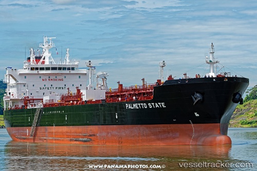
 Palmetto State
Current Status
Where is the vessel?
Palmetto State is currently in 134 nm SW of Nosara Beach, based on AIS data received about 1h ago.
Latest AIS update:
Current position: 8.36847° N, 87.22746° W (134 nm SW of Nosara Beach)
Average speed (last 7 days): Loading…
Average speed (last 30 days): Loading…
Vessel profile: Palmetto State is a Chemical Oil Products Tanker with dimensions 186m x 32m.
This page combines live AIS, route history, probable destination signals, nearby traffic, and port activity for practical vessel monitoring.
The current position of vessel Palmetto State is 8.36847 lat / -87.22746 lng. Updated: 2026-05-14 21:43:58 UTCNearest reference points:
- 67 nm SW of Sámara
- 27 nm W of Playa Conchal
- Near Golfo de Papagayo
Currently sailing under the flag of USA ![]()
Details:
Live Vessel Palmetto State Analytics (details, animations, etc.)
Recent AIS points (UTC):
2026-05-14 18:01:41 UTC · 8.16839, -86.47783 · SOG 12.3 kn · COG 285°2026-05-14 19:29:32 UTC · 8.25515, -86.77326 · SOG 12.7 kn · COG 283°
2026-05-14 19:37:31 UTC · 8.26200, -86.80008 · SOG 12.6 kn · COG 283°
2026-05-14 21:43:58 UTC · 8.36847, -87.22746 · SOG 12.3 kn · COG 280°