 vesseltracker.com
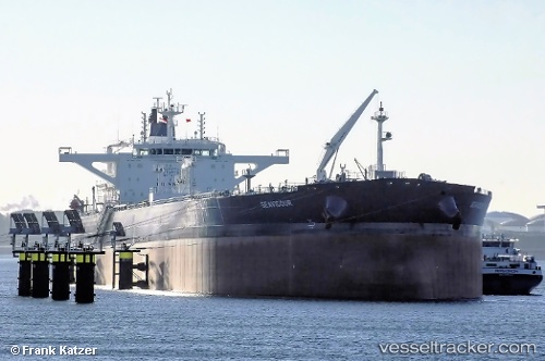
Seavigour
Current StatusWhere is the vessel?
Seavigour is currently in 127 nm NE of Dorp Rincón, based on AIS data received about 1h ago.
Latest AIS update:
Current position: 14.12189° N, 67.36732° W (127 nm NE of Dorp Rincón)
Average speed (last 7 days): Loading…
Average speed (last 30 days): Loading…
Vessel profile: Seavigour is a Crude Oil Tanker with dimensions 48m x 274m.
This page combines live AIS, route history, probable destination signals, nearby traffic, and port activity for practical vessel monitoring.
The current position of vessel Seavigour is 14.12189 lat / -67.36732 lng. Updated: 2026-03-28 13:36:22 UTCNearest reference points:
- 148 nm N of Dorp Rincón
- 82 nm S of Santa Isabel
- Near Bullenbaai
Details:
Live Vessel Seavigour Analytics (details, animations, etc.)
Recent AIS points (UTC):
2026-03-28 08:06:16 UTC · 14.57935, -68.31420 · SOG 11 kn · COG 119°2026-03-28 09:58:33 UTC · 14.42639, -68.00078 · SOG 11 kn · COG 116°
2026-03-28 12:13:17 UTC · 14.24071, -67.61438 · SOG 11.7 kn · COG 113°
2026-03-28 13:36:22 UTC · 14.12189, -67.36732 · SOG 11.4 kn · COG 114°