 vesseltracker.com
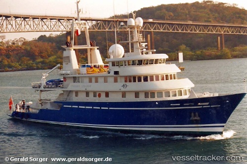
 BLUE SHADOW
Current Status
Where is the vessel?
BLUE SHADOW is currently in Near Doha, based on AIS data received about 1h ago.
Latest AIS update:
Current position: 25.29470° N, 51.55626° E (Near Doha)
Average speed (last 7 days): Loading…
Average speed (last 30 days): Loading…
Vessel profile: BLUE SHADOW is a Yacht with dimensions m x m.
This page combines live AIS, route history, probable destination signals, nearby traffic, and port activity for practical vessel monitoring.
The current position of vessel BLUE SHADOW is 25.29470 lat / 51.55626 lng. Updated: 2026-05-15 17:43:43 UTCNearest reference points:
- Near RAS LAFFAN
- Near Sitrah Anchorage
- Near KHALIFA BIN SALMAN
Currently sailing under the flag of Equatorial Guinea ![]()
Details:
Live Vessel BLUE SHADOW Analytics (details, animations, etc.)
Recent AIS points (UTC):
2026-05-15 10:02:07 UTC · 25.29484, 51.55612 · SOG 3.2 kn · COG 64°2026-05-15 15:43:06 UTC · 25.29466, 51.55629 · SOG 0.4 kn · COG 64°
2026-05-15 17:07:11 UTC · 25.29468, 51.55626 · SOG 0.3 kn · COG 64°
2026-05-15 17:43:43 UTC · 25.29470, 51.55626 · SOG 0.5 kn · COG 64°