 vesseltracker.com
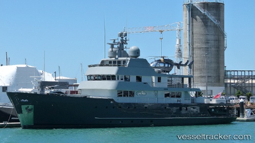
 Plan B
Current Status
Where is the vessel?
Plan B is currently in Near Gold Coast, based on AIS data received less than 1h ago.
Latest AIS update:
Current position: 27.97399° S, 153.42448° E (Near Gold Coast)
Average speed (last 7 days): Loading…
Average speed (last 30 days): Loading…
Vessel profile: Plan B is a Yacht with dimensions 49m x 10m.
This page combines live AIS, route history, probable destination signals, nearby traffic, and port activity for practical vessel monitoring.
The current position of vessel Plan B is -27.97399 lat / 153.42448 lng. Updated: 2026-05-16 08:07:45 UTCNearest reference points:
- Near Gold Coast
- Near Labrador
- Near Biggera Waters
Currently sailing under the flag of Cayman Is ![]()
Plan B built in 1973 year
Deadweight:
850 tDetails:
Live Vessel Plan B Analytics (details, animations, etc.)
Recent AIS points (UTC):
2026-05-16 04:20:26 UTC · -27.97333, 153.42332 · SOG 0 kn · COG -1°2026-05-16 06:07:45 UTC · -27.97399, 153.42448 · SOG 0 kn · COG 74°
2026-05-16 07:28:47 UTC · -27.97398, 153.42448 · SOG 0 kn · COG 74°
2026-05-16 08:07:45 UTC · -27.97399, 153.42448 · SOG 0 kn · COG 74°