 vesseltracker.com
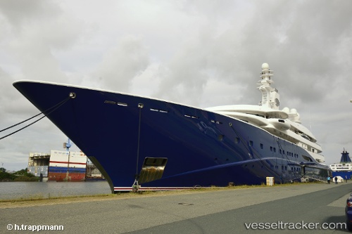
 Al Mirqab
Current Status
Where is the vessel?
Al Mirqab is currently in Near Barcelona, based on AIS data received less than 1h ago.
Latest AIS update:
Current position: 41.37790° N, 2.18483° E (Near Barcelona)
Average speed (last 7 days): Loading…
Average speed (last 30 days): Loading…
Vessel profile: Al Mirqab is a Service Ship with dimensions 133m x 20m.
This page combines live AIS, route history, probable destination signals, nearby traffic, and port activity for practical vessel monitoring.
The current position of vessel Al Mirqab is 41.37790 lat / 2.18483 lng. Updated: 2026-04-24 14:01:41 UTCNearest reference points:
- Near Barcelona
- Near Zona Franca de Barcelona
- Near BADALONA
Currently sailing under the flag of Cayman Is ![]()
Al Mirqab built in 2008 year
Deadweight:
1440 tDetails:
Live Vessel Al Mirqab Analytics (details, animations, etc.)
Recent AIS points (UTC):
2026-04-24 10:55:42 UTC · 41.37789, 2.18482 · SOG 0 kn · COG 344°2026-04-24 11:34:43 UTC · 41.37789, 2.18482 · SOG 0 kn · COG 344°
2026-04-24 13:37:41 UTC · 41.37790, 2.18483 · SOG 0 kn · COG 344°
2026-04-24 14:01:41 UTC · 41.37790, 2.18483 · SOG 0 kn · COG 344°