 vesseltracker.com
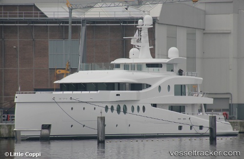
 SEA & US
Current Status
Where is the vessel?
SEA & US is currently in Near Ambarli, based on AIS data received less than 1h ago.
Latest AIS update:
Current position: 40.96188° N, 28.65623° E (Near Ambarli)
Average speed (last 7 days): Loading…
Average speed (last 30 days): Loading…
Vessel profile: SEA & US is a Houseboat with dimensions 63m x 10m.
This page combines live AIS, route history, probable destination signals, nearby traffic, and port activity for practical vessel monitoring.
The current position of vessel SEA & US is 40.96188 lat / 28.65623 lng. Updated: 2026-05-13 19:17:28 UTCNearest reference points:
- Near Ambarli
- Near Küçükçekmece
- Near Gürpinar
Currently sailing under the flag of Malaysia ![]()
SEA & US built in 2018 year
Deadweight:
254 tDetails:
Live Vessel SEA & US Analytics (details, animations, etc.)
Recent AIS points (UTC):
2026-05-13 16:24:24 UTC · 40.96188, 28.65623 · SOG 0 kn · COG 54°2026-05-13 17:09:12 UTC · 40.96188, 28.65624 · SOG 0 kn · COG 53°
2026-05-13 18:17:22 UTC · 40.96188, 28.65623 · SOG 0 kn · COG 54°
2026-05-13 19:17:28 UTC · 40.96188, 28.65623 · SOG 0 kn · COG 54°