 vesseltracker.com
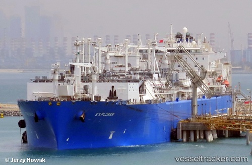
 Ss Explorer
Current Status
Where is the vessel?
Ss Explorer is currently in Near Jebel Ali Free Zone, based on AIS data received about 113d ago.
Latest AIS update:
Current position: 25.03123° N, 55.06763° E (Near Jebel Ali Free Zone)
Average speed (last 7 days): Loading…
Average speed (last 30 days): Loading…
Vessel profile: Ss Explorer is a Fsru Tanker with dimensions 291m x 44m.
This page combines live AIS, route history, probable destination signals, nearby traffic, and port activity for practical vessel monitoring.
The current position of vessel Ss Explorer is 25.03123 lat / 55.06763 lng. Updated: 2026-01-21 09:02:05 UTCNearest reference points:
- Near Jebel Ali Free Zone
- Near Jebel Ali
- Near DUBAI MARINA
Currently sailing under the flag of Belgium ![]()
Ss Explorer built in 2008 year
Deadweight:
82500 tDetails:
Live Vessel Ss Explorer Analytics (details, animations, etc.)
Recent AIS points (UTC):
2026-01-21 09:02:05 UTC · 25.03123, 55.06763 · SOG 0 kn · COG 255°