 vesseltracker.com
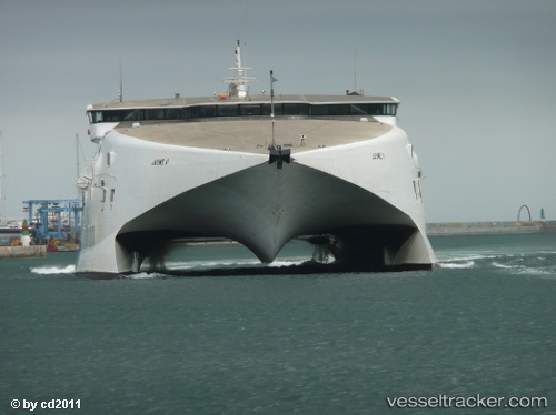
 Jaume Ii
Current Status
Where is the vessel?
Jaume Ii is currently in Near Freeport, based on AIS data received about 1h ago.
Latest AIS update:
Current position: 26.51942° N, 78.77305° W (Near Freeport)
Average speed (last 7 days): Loading…
Average speed (last 30 days): Loading…
Vessel profile: Jaume Ii is a Passenger Ro Ro Cargo Ship with dimensions 81m x 28m.
This page combines live AIS, route history, probable destination signals, nearby traffic, and port activity for practical vessel monitoring.
The current position of vessel Jaume Ii is 26.51942 lat / -78.77305 lng. Updated: 2026-04-25 23:00:37 UTCNearest reference points:
- 44 nm S of Freeport
- 44 nm E of Surfside
- Near Palm Beach
Currently sailing under the flag of Cyprus ![]()
Jaume Ii built in 1996 year
Deadweight:
310 tDetails:
Live Vessel Jaume Ii Analytics (details, animations, etc.)
Recent AIS points (UTC):
2026-04-25 18:43:25 UTC · 26.08655, -80.11611 · SOG 0 kn · COG 0°2026-04-25 22:18:22 UTC · 26.51118, -78.78023 · SOG 12.2 kn · COG 225°
2026-04-25 22:22:27 UTC · 26.49747, -78.80927 · SOG 29.9 kn · COG 250°
2026-04-25 23:00:37 UTC · 26.51942, -78.77305 · SOG 0 kn · COG 322°