 vesseltracker.com
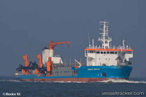
 Beachway
Current Status
Where is the vessel?
Beachway is currently in Near Malabon, based on AIS data received about 1h ago.
Latest AIS update:
Current position: 14.61730° N, 120.89502° E (Near Malabon)
Average speed (last 7 days): Loading…
Average speed (last 30 days): Loading…
Vessel profile: Beachway is a Hopper Dredger with dimensions 119m x 119m.
This page combines live AIS, route history, probable destination signals, nearby traffic, and port activity for practical vessel monitoring.
The current position of vessel Beachway is 14.61730 lat / 120.89502 lng. Updated: 2026-05-02 12:03:52 UTCNearest reference points:
- Near Tondo
- Near Malabon
- Near Caloocan City
Currently sailing under the flag of Cyprus ![]()
Beachway built in 2010 year
Deadweight:
7445 tDetails:
Live Vessel Beachway Analytics (details, animations, etc.)
Recent AIS points (UTC):
2026-05-02 07:25:12 UTC · 14.61347, 120.88108 · SOG 12 kn · COG 67°2026-05-02 09:57:12 UTC · 14.58699, 120.80766 · SOG 11.7 kn · COG 74°
2026-05-02 10:27:13 UTC · 14.62054, 120.90055 · SOG 12.2 kn · COG 77°
2026-05-02 12:03:52 UTC · 14.61730, 120.89502 · SOG 11.4 kn · COG 250°