 vesseltracker.com
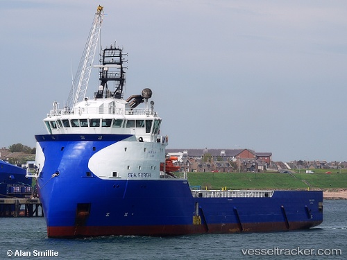
 Sea Forth
Current Status
Where is the vessel?
Sea Forth is currently in Near Island View, based on AIS data received less than 1h ago.
Latest AIS update:
Current position: 29.87758° S, 31.02910° E (Near Island View)
Average speed (last 7 days): Loading…
Average speed (last 30 days): Loading…
Vessel profile: Sea Forth is a Offshore Tug Supply Ship with dimensions 89m x 20m.
This page combines live AIS, route history, probable destination signals, nearby traffic, and port activity for practical vessel monitoring.
The current position of vessel Sea Forth is -29.87758 lat / 31.02910 lng. Updated: 2026-04-28 19:02:32 UTCNearest reference points:
- Near Island View
- Near Durban
- Near Umhlanga Rocks
Currently sailing under the flag of Cyprus ![]()
Sea Forth built in 2013 year
Deadweight:
4700 tDetails:
Live Vessel Sea Forth Analytics (details, animations, etc.)
Recent AIS points (UTC):
2026-04-28 16:02:33 UTC · -29.87757, 31.02911 · SOG 0 kn · COG 200°2026-04-28 16:14:32 UTC · -29.87754, 31.02913 · SOG 0 kn · COG 200°
2026-04-28 18:02:32 UTC · -29.87754, 31.02911 · SOG 0 kn · COG 200°
2026-04-28 19:02:32 UTC · -29.87758, 31.02910 · SOG 0 kn · COG 200°