 vesseltracker.com
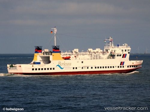
 Muensterland
Current Status
Where is the vessel?
Muensterland is currently in Near Delfzijl, based on AIS data received less than 1h ago.
Latest AIS update:
Current position: 53.32788° N, 6.93415° E (Near Delfzijl)
Average speed (last 7 days): Loading…
Average speed (last 30 days): Loading…
Vessel profile: Muensterland is a Passenger Ro Ro Cargo Ship with dimensions 78m x 12m.
This page combines live AIS, route history, probable destination signals, nearby traffic, and port activity for practical vessel monitoring.
The current position of vessel Muensterland is 53.32788 lat / 6.93415 lng. Updated: 2026-04-22 22:03:16 UTCNearest reference points:
- Near APPINGEDAM
- Near Emden
- Near Kolham
Currently sailing under the flag of Germany ![]()
Muensterland built in 1986 year
Deadweight:
572 tDetails:
Live Vessel Muensterland Analytics (details, animations, etc.)
Recent AIS points (UTC):
2026-04-22 19:32:44 UTC · 53.32785, 6.93416 · SOG 0 kn · COG 3°2026-04-22 20:00:17 UTC · 53.32787, 6.93417 · SOG 0 kn · COG 4°
2026-04-22 21:44:52 UTC · 53.32794, 6.93411 · SOG 0 kn · COG 3°
2026-04-22 22:03:16 UTC · 53.32788, 6.93415 · SOG 0 kn · COG 4°