 vesseltracker.com
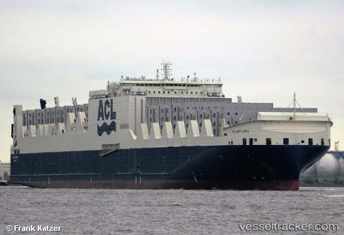
 ATLANTIC SEA
Current Status
Where is the vessel?
ATLANTIC SEA is currently in Near Sewell's Point, based on AIS data received about 1h ago.
Latest AIS update:
Current position: 36.90620° N, 76.32650° W (Near Sewell's Point)
Average speed (last 7 days): Loading…
Average speed (last 30 days): Loading…
Vessel profile: ATLANTIC SEA is a Container Ro-Ro Cargo Ship with dimensions 296m x 38m.
This page combines live AIS, route history, probable destination signals, nearby traffic, and port activity for practical vessel monitoring.
The current position of vessel ATLANTIC SEA is 36.9062 lat / -76.3265 lng. Updated: 2026-04-24 16:45:43 UTCNearest reference points:
- Near Sewell's Point
- Near Norfolk
- Near Hampton Roads Pt
Currently sailing under the flag of Malta ![]()
ATLANTIC SEA built in 2016 year
Deadweight:
55738 tDetails:
Live Vessel ATLANTIC SEA Analytics (details, animations, etc.)
Recent AIS points (UTC):
2026-04-24 13:22:11 UTC · 36.90610, -76.32640 · SOG 0 kn · COG 352°2026-04-24 14:00:43 UTC · 36.90610, -76.32650 · SOG 0 kn · COG 352°
2026-04-24 16:21:42 UTC · 36.90610, -76.32650 · SOG 0 kn · COG 352°
2026-04-24 16:45:43 UTC · 36.90620, -76.32650 · SOG 0 kn · COG 352°