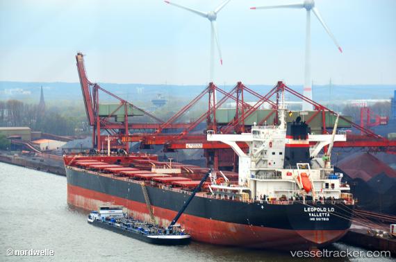
.
Vessel photo of Leopold Ld (IMO 9617519) vesseltracker.com

Leopold Ld

Vessel type: Bulk Carrier | IMO: 9617519 | MMSI: MMSI: 229531000
Call sign: 9HA3383 | Dimensions: 45 m x 292 m
Current Status

Where is the vessel?

Leopold Ld is currently in 64 nm W of Tusdeer Free Zone, based on AIS data received about 971d ago.

Latest AIS update:

Current position: 21.51593° N, 38.00945° E (64 nm W of Tusdeer Free Zone)

Average speed (last 7 days): Loading…

Average speed (last 30 days): Loading…

Vessel profile: Leopold Ld is a Bulk Carrier with dimensions 45m x 292m.

This page combines live AIS, route history, probable destination signals, nearby traffic, and port activity for practical vessel monitoring.

The current position of vessel Leopold Ld is 21.51593 lat / 38.00945 lng. Updated: 2023-08-26 14:23:30 UTC
Nearest reference points:
  • 64 nm W of Tusdeer Free Zone
  • 67 nm W of Tusdeer Free Zone
  • 65 nm SW of King Abdullah City
Details:

Live Vessel Leopold Ld Analytics (details, animations, etc.)


Recent AIS points (UTC):
2023-08-26 14:23:30 UTC · 21.51593, 38.00945 · SOG 9.6 kn · COG 332°

Track of the vessel in the last 60 days


UTC: --
Start: -- Track timeline (UTC) End: --
Encountered: --


Link to the map:


Find another ship

Leopold_Ld (229531000) last ports (portcalls and passsages)

Wusong | 2023-06-08 20:50:48
Taicang | 2023-06-05 18:35:55
Singapore | 2023-05-19 21:18:35
Port Louis | 2023-05-04 08:15:16
Port Louis | 2023-04-30 07:13:06
Algeciras | 2023-03-08 05:56:23
Port Said | 2023-02-27 14:45:16
Bur Ibrahim | 2023-02-27 05:02:25
Ayn Sukhnah | 2023-02-26 12:04:05
Ra’S Shukhayr | 2023-02-22 05:49:47
Sitrah Anchorage | 2023-02-04 14:51:31
Jubail | 2023-02-03 20:45:05
Jubail | 2023-01-30 17:54:18
Sitrah Anchorage | 2023-01-26 05:25:17
Umm Said | 2023-01-25 06:07:28
Umm Said | 2023-01-21 03:02:15
Port Said | 2023-01-06 05:15:52
Narvik | 2022-12-15 14:39:40
Narvik | 2022-12-11 14:03:31
Cape Of Good Hope | 2022-10-07 04:10:43
Sambu | 2022-07-04 08:03:13
Panamburu | 2022-04-15 03:45:04