 vesseltracker.com
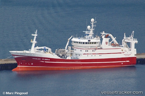
 BIRITA
Current Status
Where is the vessel?
BIRITA is currently in 22 nm SW of Vágur, based on AIS data received less than 1h ago.
Latest AIS update:
Current position: 61.19209° N, 7.33989° W (22 nm SW of Vágur)
Average speed (last 7 days): Loading…
Average speed (last 30 days): Loading…
Vessel profile: BIRITA is a Fishing Vessel with dimensions 60m x 13m.
This page combines live AIS, route history, probable destination signals, nearby traffic, and port activity for practical vessel monitoring.
The current position of vessel BIRITA is 61.19209 lat / -7.33989 lng. Updated: 2026-04-27 22:10:11 UTCNearest reference points:
- 20 nm S of Vágur
- Near VESTMANNA
- Near FUGLAFJORDUR
Currently sailing under the flag of Faroe Islands ![]()
BIRITA built in 2000 year
Deadweight:
0 tDetails:
Live Vessel BIRITA Analytics (details, animations, etc.)
Recent AIS points (UTC):
2026-04-27 18:12:15 UTC · 61.23840, -7.39499 · SOG 1.4 kn · COG 114°2026-04-27 19:24:12 UTC · 61.23104, -7.34334 · SOG 0.2 kn · COG 107°
2026-04-27 19:54:15 UTC · 61.23007, -7.33882 · SOG 0.3 kn · COG 88°
2026-04-27 22:10:11 UTC · 61.19209, -7.33989 · SOG 3.1 kn · COG 324°