 vesseltracker.com
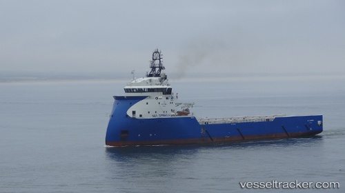
 SPRINGER TIDE
Current Status
Where is the vessel?
SPRINGER TIDE is currently in Near Captain Field, based on AIS data received less than 1h ago.
Latest AIS update:
Current position: 58.30642° N, 1.76591° W (Near Captain Field)
Average speed (last 7 days): Loading…
Average speed (last 30 days): Loading…
Vessel profile: SPRINGER TIDE is a Other Type with dimensions m x m.
This page combines live AIS, route history, probable destination signals, nearby traffic, and port activity for practical vessel monitoring.
The current position of vessel SPRINGER TIDE is 58.30642 lat / -1.76591 lng. Updated: 2026-04-25 01:33:45 UTCNearest reference points:
- Near Peterhead
- Near PETERHEAD
- Near Aberdeen
Currently sailing under the flag of United Kingdom ![]()
Details:
Live Vessel SPRINGER TIDE Analytics (details, animations, etc.)
Recent AIS points (UTC):
2026-04-24 22:45:06 UTC · 58.26689, -1.75192 · SOG 0.2 kn · COG 4°2026-04-24 23:54:07 UTC · 58.26691, -1.74260 · SOG 0.6 kn · COG 349°
2026-04-25 01:30:36 UTC · 58.30643, -1.76591 · SOG 0.9 kn · COG 134°
2026-04-25 01:33:45 UTC · 58.30642, -1.76591 · SOG 0.5 kn · COG 134°