 vesseltracker.com
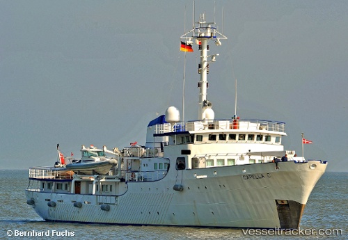
 Capella C
Current Status
Where is the vessel?
Capella C is currently in Near Pioneer, based on AIS data received less than 1h ago.
Latest AIS update:
Current position: 1.30121° N, 103.67981° E (Near Pioneer)
Average speed (last 7 days): Loading…
Average speed (last 30 days): Loading…
Vessel profile: Capella C is a Yacht with dimensions 60m x 10m.
This page combines live AIS, route history, probable destination signals, nearby traffic, and port activity for practical vessel monitoring.
The current position of vessel Capella C is 1.30121 lat / 103.67981 lng. Updated: 2026-05-14 15:36:14 UTCNearest reference points:
- Near Tuas
- Near Pulau Ayer Chawan
- Near PASIR PANJANG Terminal
Currently sailing under the flag of United Kingdom ![]()
Capella C built in 1968 year
Details:
Live Vessel Capella C Analytics (details, animations, etc.)
Recent AIS points (UTC):
2026-05-14 12:18:17 UTC · 1.30125, 103.67972 · SOG 0 kn · COG 262°2026-05-14 13:27:16 UTC · 1.30150, 103.68008 · SOG 0 kn · COG 262°
2026-05-14 14:24:14 UTC · 1.30139, 103.68021 · SOG 0 kn · COG 262°
2026-05-14 15:36:14 UTC · 1.30121, 103.67981 · SOG 0.1 kn · COG 262°