 vesseltracker.com
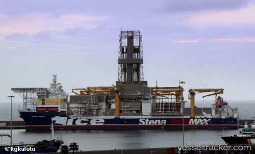
Stena Icemax
Current StatusWhere is the vessel?
Stena Icemax is currently in 42 nm W of Bnei Darom, based on AIS data received about 1h ago.
Latest AIS update:
Current position: 32.07833° N, 30.92700° E (42 nm W of Bnei Darom)
Average speed (last 7 days): Loading…
Average speed (last 30 days): Loading…
Vessel profile: Stena Icemax is a Drilling Ship with dimensions 42m x 228m.
This page combines live AIS, route history, probable destination signals, nearby traffic, and port activity for practical vessel monitoring.
The current position of vessel Stena Icemax is 32.07833 lat / 30.92700 lng. Updated: 2026-04-28 07:35:46 UTCNearest reference points:
- Near Damietta
- 21 nm N of Port Said
- Near Alexandria
Details:
Live Vessel Stena Icemax Analytics (details, animations, etc.)
Recent AIS points (UTC):
2026-04-28 04:41:46 UTC · 32.07817, 30.92683 · SOG 0 kn · COG 339°2026-04-28 05:46:56 UTC · 32.07817, 30.92683 · SOG 0 kn · COG 339°
2026-04-28 07:04:05 UTC · 32.07833, 30.92700 · SOG 0 kn · COG 349°
2026-04-28 07:35:46 UTC · 32.07833, 30.92700 · SOG 0 kn · COG 350°