 vesseltracker.com
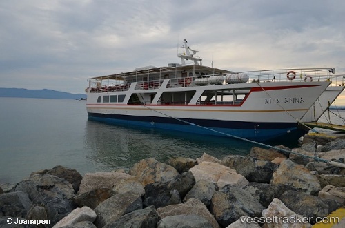
 Agia Anna
Current Status
Where is the vessel?
Agia Anna is currently in Near Moní Vatopedíou, based on AIS data received about 13h ago.
Latest AIS update:
Current position: 40.28076° N, 24.14832° E (Near Moní Vatopedíou)
Average speed (last 7 days): Loading…
Average speed (last 30 days): Loading…
Vessel profile: Agia Anna is a Passenger Ro Ro Cargo Ship with dimensions 32m x 8m.
This page combines live AIS, route history, probable destination signals, nearby traffic, and port activity for practical vessel monitoring.
The current position of vessel Agia Anna is 40.28076 lat / 24.14832 lng. Updated: 2026-04-30 13:35:04 UTCNearest reference points:
- Near Ammoulianí
- 11 nm S of Eleftheres
- 20 nm S of Ágios Efstrátios
Currently sailing under the flag of Greece ![]()
Details:
Live Vessel Agia Anna Analytics (details, animations, etc.)
Recent AIS points (UTC):
2026-04-30 13:35:04 UTC · 40.28076, 24.14832 · SOG 9 kn · COG -1°2026-04-30 13:35:04 UTC · 40.28076, 24.14832 · SOG 9 kn · COG -1°
2026-04-30 13:35:04 UTC · 40.28076, 24.14832 · SOG 9 kn · COG -1°
2026-04-30 13:35:04 UTC · 40.28076, 24.14832 · SOG 9 kn · COG -1°